OLDONYOLENGAI CLIMB
Oldoinyo Lengai Mountain & Surroundings.
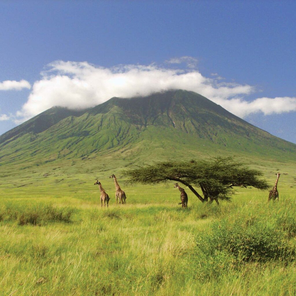
Ol Doinyo Lengai is a stratovolcanic mountain located northeast of Ngorongoro Conservation Area, rises abruptly above the rift valley plains south of Lake Natron, with 2.751meters above sea level. Ol Doinyo Lengai is the only remaining active volcanic mountain in Tanzania (major explosive eruptions have been recorded since 2007) though there are numerous small eruptions happen now and then. It is the only volcano in the world that erupt natrocarbonatite lava, highly fluid lava that contains almost no silicon. Natrocarbonatite lava is also much cooler than other lavas
The mountain is ideal for adventurous travelers who like to explore those unique areas in the world, such as photographers, trekkers, and volcano lovers. Nevertheless, Ol Doinyo Lengai is considered to be extremely hazardous and that safety cannot be assured. Trekking takes 1 day; though descending is tough’ It is always done in combination with a safari to Serengeti and Ngorongoro
It provides a spectacular view of the escarpment separating the Serengeti Plains from Lake Natron and the Rift Valley below.
Ol doinyo Lengai worshiped by “Maasai as Mountain of God” is located in the African Rift valley about 120 km northwest of Arusha. It is a nice safari when you combine it with Ngorongoro Highland Hiking, which gives the opportunity to explore the culture and view different volcanic features along the way before climbing the mountain. The climbing takes about 3 to 4 hours to reach the top, and the hike normally starts early hours of the morning to avoid the day intense heat in the Rift Valley; the best time to climb is from June to early March.
Extra activities include:
Lake Natron
Hot spring
Maasai bomas
Waterfalls
Hiking
Distances: 4 hours from Arusha, 2 hours to Lake Manyara, 2.30 hours, and 2.30 hours to Tarangire.
For more information on here please contact us.
Lake Natron & Ol Doinyo Lengai
Lake Natron and Mt. Ol Doinyo Lengai are part of an untouched land of ancient origin in the northeast of Tanzania in-between the Ngorongoro Highlands and Serengeti plains. This area is home of the Maasai, who have kept all their customs and have hardly been influenced by modern culture. Here, it is the remoteness and the dramatic landscape, rather than the variety of animals that exert a powerful attraction.
The symmetrical Ol Doinyo Lengai is the only volcano known to have erupted carbonatite tephras and lavas in historical time.
The prominent stratovolcano, known to the Maasai as “The Mountain of God,” rises abruptly above the broad plain south of Lake Natron in the Gregory Rift Valley.
The cone-building stage ended about 15,000 years ago and was followed by periodic ejection of natrocarbonatitic and nephelinite tephra during the Holocene. Historical eruptions have consisted of smaller tephra ejections and emission of numerous natrocarbonatitic lava flows on the floor of the summit crater and occasionally down the upper flanks.
Ol Doinyo Lengai is an extremely fascinating volcano: it is the only active volcano known to erupt carbonatite lava, a sensational discovery scientists made as recently as in the 1960s: the lavas it erupts are NOT melts based on silica, but on natroncarbonate!
Thus, the temperatures of these lavas are much lower, “only” about 600 deg. C., and Lengai’s lava does not emit enough light to glow during day,- only at night, a dull reddish glow that does not illuminate anything is visible. Also because of its peculiar chemical composition, the lava is extremely fluid and behaves very much like water, with the exception that it is black like oil. After it is cooled down it quickly alters and becomes a whitish powder.
Geologically, the present-day cone of the volcano was constructed about 15,000 years ago. Historical eruptions have been moderate to small explosive events. In addition to its intermittent explosive activity at intervals of typically years or decades, numerous natrocarbonitite lava flows have been erupted from vents on the floor of the active summit crater.
The depth and morphology of the active (northern) crater have changed dramatically during the course of historical eruptions, ranging from steep craters walls about 200 m deep in the mid-20th century to shallow platforms mostly filling the crater. Long-term lava effusion in the summit crater beginning in 1983 had by the turn of the century mostly filled the northern crater; by late 1998 uptill today lava had begun overflowing the crater rim.
The depth and morphology of the northern crater have changed dramatically during the course of historical eruptions, ranging from steep crater walls about 200 m deep in the mid-20th century to shallow platforms mostly filling the crater.
Long-term lava effusion in the summit crater beginning in 1983 had by the turn of the century mostly filled the northern crater; by late 1998 lava had begun overflowing the crater rim.
2.5 million lesser flamingos take shelter in Lake Natron, making it a spectacular place. The ash and lava deposits from Ol Donyo Lengai give the lake a high saline content and transform it into a very important eco-system. Its surface has impressive purple and red brown colouring which is caused by millions of Cyanobacteria and Spirulina algae. These constitute the basic source of nutrition for the flamingos who build their nests on the water surface. Periodically, large parts of the lake are dried out and the place turns into an impressive white lunar landscape. Giraffes, zebras and other mammals are often seen nearby.
This unique area, although it is very warm, is great for walking and photo shooting. Our walk will take us to the nearby Ngare Sero River that forms beautiful waterfalls on the rim of the Great Rift Valley. These waterfalls in turn disgorge into Lake Natron. Hiking through a gorge, we reach the Munge waterfalls that create a natural Jacuzzi type pool where you can enjoy swimming. African people believe that this area is bursting with positive energy and bathing here washes out all troubles and sins.
At the eastern side of the lake is the massive Mount Lengai with a height of 2,941 m. Ol Donyo Lengai in the Maasai language means ‘Mountain of God’. It is estimated to be about 350,000 – 400,000 years old. It is an active volcano whose last recorded eruption happened in 1966 and lesser eruptions in 2007 and 2008.
The foothills of the mountain are green and Maasai are often seen grazing their cattle and goats. When there is no fear of a sudden eruption, we can arrange a climb up to the top of the volcano so that adventurous visitors can admire the steaming crater and the lava flows. Other visitors prefer to view its symmetrical cone from a distance and to enjoy the great views of the surrounding landscapes of the Rift Valley. We start this ascent very early in the morning so that we can reach the top in time to watch the magnificent sunrise.
This trekking route to Lake Natron, the waterfalls and Mt. Ol Doinyo Lengai is one of the highlights of the activities of Active Tanzania Adventures. It offers an off the beaten track excursion to places of extraordinary natural beauty.
This excursion can be arranged all year round. We either stay in beautiful tented camps, or we use our own gear to camp in public campsites. Have a look at our itinerary and contact us to arrange this special excursion together.
Lava containing observed from the active cone during March and July 2014
Volcanism has continued at Ol Doinyo Lengai through July 2015. Though the volcano has been erupting since 1983 (with three breaks of about a year each), the currently active spatter cone within the N crater was first noted in April 2013.
During March 2014, Baraka Mollel observed activity in the crater and on the cracked terrain near the trail to the summit. This report also includes a description of the 20th-21st July 2015 visit by a G.U geological team leaded by DK Daniel.
Observations in June 2015,Timoth Garia and Baraka Mollel who are specialist guide for Trekking Volcano mountain in Tanzania photographed the active N crater with the aid of GU geologist and Timoth reported that an overhang had formed on the W side of the near-vertical pit wall above the active cone (figure 1). Erosion was most noticeable where the near-vertical walls met the slope to the rim. Inside the pit, erosion appeared at the boundaries between layers.Timoth also noted a large crack located above the climbing route near the outside of the rim.
G.U geologists that had climbed Ol Doinyo Lengai on 20 June 2015 saw periodic eruptions from a small fissure, and steam emissions from an area of the crater rim next to a part that had collapsed. Another group of geologists that visited during 14-15 February noted three new hornitos on the W part of the crater floor that were black and very fresh. They also noted a cone-shaped gray hornito on the middle of the floor and a new black lava flow to the S.
Ash eruption from Ol Doinyo Lengai seen on 12 March 2008 from the NNE. The image of 2008 showed that the E, N, and W flanks of the ash cone had buried the original crater rim. Over-steepening of the cone flank in places resulted in small landslides which can be seen just below the cone as dark material covering the lighter areas of older weathered carbonatite. The peak beyond the ash plume is the summit.
Oldoinyo Lengai Itinerary – 2days / 1 nights
From Moshi or Arusha it is better to allow 2 days for the trip – 6 hours to drive from Moshi to Lake Natron for dinner and overnight.
Day 1: Drive from Moshi to Arusha , game drive and overnight at Ngosek guest house in Ngare sero source – a magnificent rock amphitheatre with springs gushing out of rock faces.
Day 2: 10.30PM Drive to the base of the climb, ascend to the summit (maximum 6 hours) and if it’s possible, descend into the active crater then walk down. Lunch at Ngare sero and drive back to Moshi/Arusha town
The cost of the trip is $270usd per person.
Standing at 2,878 meters above the Soda Ash Lake Natron, Mountain of GOD as famous to the Maasai community that inhabit the area, Mountain Ol’doinyo Lengai is situated in the Ngorongoro highlands and the African Rift valley about 120 kilometers Northwest of Arusha, Tanzania.
Since the past ancestors the Holly Lengai has been used by Maasai for their prayer to their GOD known as NGAI. Ol’doinyo Lengai is the only active volcano in the world that erupt natrocarbonatite lava which is cooler than other lavas about (510 degrees C) compare to the temperatures of basaltic lavas (1,100 degrees C) with less silicon.
The Mountain frequently does minor eruptions and form cone like structures to its crater base.
While on the summit of Mountain Ol’doinyo Lengai one can sight clearly the Soda Lake Natron which accommodates and consist of good nesting sites for different bird species especially the Flamingos, pelicans and geese more than 350 different types are recorded to date.
Unlike others two highest Mountains, Lengai takes about six to seven hours to the summit crater. Also the Mountain is an ideal place for a working safari escort by the Maasai guides with weapons tourist can sight wild animals like olive baboon, velvet, monitor lizard, hyenas, lion, leopard, jackal, Grant’s gazelle, impala and zebra.
The nearby are the Maasai BOMAS that gives you a chance to interact with the indigenous learn their cultures, taboos and traditional.
Oldoinyo Lengai Mountain & Surroundings
Ol Doinyo Lengai is a stratovolcanic mountain located northeast of Ngorongoro Conservation Area, rises abruptly above the rift valley plains south of Lake Natron, with 2.751meters above sea level. Ol Doinyo Lengai is the only remaining active volcanic mountain in Tanzania (major explosive eruptions have been recorded since 2007) though there are numerous small eruptions happen now and then.
It is the only volcano in the world that erupt natrocarbonatite lava, highly fluid lava that contains almost no silicon. Natrocarbonatite lava is also much cooler than other lavas
The mountain is ideal for adventurous travelers who like to explore those unique areas in the world, such as photographers, trekkers and volcano lovers. Nevertheless Ol Doinyo Lengai is considered to be extremely hazardous and that safety cannot be assured.
Trekking takes 1 day; though descending is tough’ It is always done with combination with safari to Serengeti and Ngorongoro
It provides spectacular view of escarpment separating the Serengeti Plains from Lake Natron and the Rift Valley below.
Ol doinyo Lengai worshiped by “Maasai as Mountain of God” is located in the African Rift valley about 120 km North West of Arusha. It is nice safari when you combine with Ngorongoro Highland Hiking, which gives the opportunity to explore culture and view different volcanic features along the way before climbing the mountain.
The climbing takes about 3 to 4 hours to reach the top, and the hike normally starts early hours in the morning to avoid the day intense heat in the Rift Valley; the best time to climb is from June to early March.
Extra activities include:
- Lake Natron
- Hot spring
- Maasai bomas
- Waterfalls
- Hikking
Distances: 4 hours from Arusha, 2 hours to Lake Manyara, 2.30 hours, and 2.30 hours to Tarangire.
For more information on here please contact us.


